Injured Harlin calls off adventure
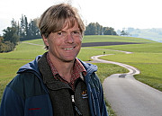
John Harlin, the American mountaineer attempting to trace the entire Swiss border under his own power, has taken a big fall and broken bones in both feet.
He will be in casts for six weeks and will then need physiotherapy. He is being treated at the hospital in Sion.
Harlin told swissinfo.ch he was “lucky to be alive” and hadn’t given up on the challenge, but under the circumstances it was unrealistic to hope to conclude the project this year.
The accident happened at about 10.45 on Thursday morning while Harlin was climbing in the Swiss side of Aiguilles Rouges du Dolent, a range situated between Tour Noir and Mont Dolent.
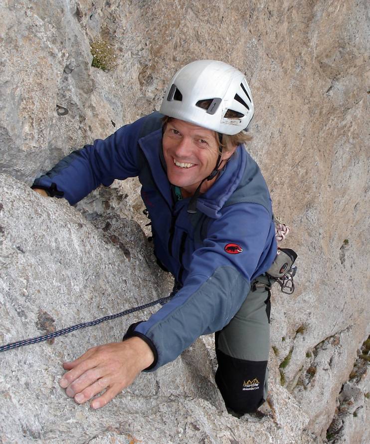
The 54-year-old adventurer, who otherwise is in good spirits, was on day nine of his planned three-month tour.
Harlin and his climbing partner Cameron Burns were at 3,500 metres when a piece of rock broke loose.
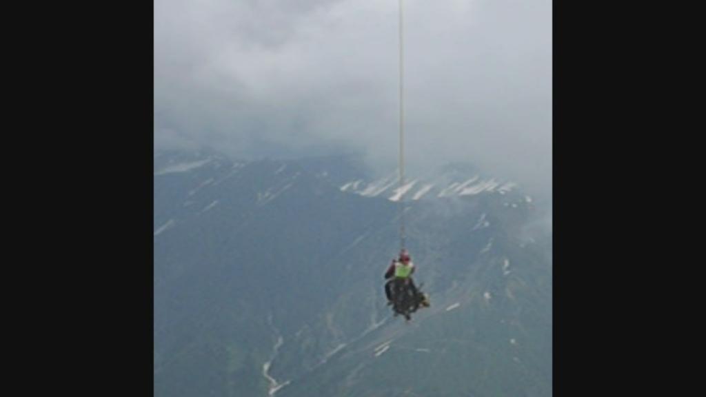
Harlin, who was leading the pitch, fell 15-20 metres with rock crumbling all around him. One of his two ropes was cut on slate rock, but the other rope held.
However, he broke four bones in his left foot, one in his right foot and will be in a cast for six weeks.
In his immediate diagnosis sent to swissinfo.ch from the mountain, Harlin thought he might have broken a rib. But then his feet starting hurting more and more.
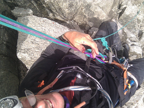
He has been sending photos and videos to swissinfo.ch on a daily basis. He even first reported his accident on the website – including a picture of him hanging injured from a rope.
Challenging
John Harlin was the star of the smash IMAX movie “The Alps” and returned to Switzerland hoping for another epic adventure that would have made climbing the Eiger look easy.
“About 2,000km,” he told swissinfo.ch before he set off, a map of the country splayed out before him. “But when you consider all the up and down, it’s probably going to be more.”
Harlin, an accomplished American mountaineer and writer, explained the idea was to stay “within a stone’s throw” of the border, dropping down to villages when he could to gather supplies.
The challenges were huge. Up and over icy 4,000m peaks, down the burbling Rhine and along the gentle crest of the Jura many weeks later, Harlin planned to climb, row and sweat his way counter clockwise back to where it all began on June 22 – St Gingolph in canton Valais.
“I feel most at home in the mountains and Switzerland is the home of mountains,” he said. “I’ve been wanting to do this for a very long time.”
On his travels, Harlin planned to meet fellow alpinists, scientists, historians and others to hear stories and paint a meticulous and nuanced picture of the country viewed from the geographical, political and cultural lines that hold it together.
A good adventure
Harlin is no stranger to challenges or to Switzerland, which came together in 1966 to produce a life-changing event.
His story has been the subject of a book and the IMAX movie, which follows Harlin back to his boyhood home of Leysin in Vaud. His mother was offered a job at the international school there in the early 1960s, while his father, John, served in the US Air Force in Germany and had become famous for climbing daring routes in the Alps.
“We once got a post card addressed to ‘Eiger John, Switzerland’,” Harlin said. “As a boy, it was a dream to live here. Dad had wanted to take me up the Matterhorn but that never happened.”
When Harlin was nine, his father was putting up the hardest route on the terrifying north face of the Eiger when his rope snapped, sending him cartwheeling to his death. Some four decades later, Harlin returned with a film crew to climb the same route.
The movie proved to be a hit as much for the scenery as for the story and Harlin has spent the past few years on a world tour to promote it. But unlike that project – which involved numerous re-enactments and actors taking his place on the peak from time to time – swissinfo’s Border Stories expedition was 100 per cent real.
“I’m looking forward to telling a story that isn’t so personal,” he said. “It’s just a good, solid adventure.”
Unfortunately, it’s an adventure that will have to wait at least another year.
swissinfo.ch
There is nothing inevitable about Switzerland’s modern borders. They cut across language, religious and geographical areas.
The period from 1798 to 1815 saw many changes.
In 1798 the allied towns of Geneva and Mulhouse became part of France. In 1802 Valais was detached from the Helvetic Republic. For a few years it was independent, but in 1810 Napoleon made it part of France.
With Valais separated from Switzerland, the French had two important passes in their hands – the Simplon and the Grand St Bernard – and no longer needed the right to march through Swiss territory.
Switzerland also gained some territory: the former Austrian possession of the Fricktal on the Rhine just east of Basel. The French invaded it in 1799, but made it part of the Helvetic Republic in 1802 as a separate canton. It eventually became part of the new canton of Aargau, and has remained so ever since.
Graubünden changed hands several times between the French and the Austrians in 1799-1800, but the French were eventually victorious. In 1801 Napoleon made it Switzerland’s 16th canton. Nevertheless, portions of the old canton remain part of modern-day Italy.
Source: swissworld.org
With so much rock and ice lining the border with Switzerland’s southern neighbours, scientists say a changing climate will have unusual impacts.
Around ten per cent of the 750km border between Switzerland and Italy, traditionally marked by a high-point on a ridge between the two, will be affected as ice melts to change the shape of the ridge. In some places it will move 100 metres at most, authorities say.
When the border was devised, officials defined it along text descriptions, which now have to be matched to geographic coordinates.
The border should have changed as glaciers moved, but no one has done so up to now.
Daniel Gutknecht from Switzerland’s topographical service says that as rock faces become exposed, officials will be able to determine more permanent spots to mark the border.

In compliance with the JTI standards
More: SWI swissinfo.ch certified by the Journalism Trust Initiative
You can find an overview of ongoing debates with our journalists here. Please join us!
If you want to start a conversation about a topic raised in this article or want to report factual errors, email us at english@swissinfo.ch.