The Rhine recovers, but slowly
From the Rhine’s alpine source to the riverbanks of industrial Basel, swissinfo.ch explores the Swiss stretch of the vital European waterway. The many dams on this section continue to destroy fish spawning grounds and habitats - but there are signs of recovery.

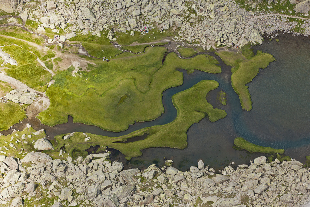
The sweet icy fluid courses through my system jolting me back into life. Cupping my hands together I greedily gulp down another mouthful from one of the streams running into Lai da Tuma, the Romansh name for the 2,345-metre-high meltwater lake considered the source of the Rhine.
Unlike my local guide Marta, I’m out of breath after our 1.5-hour climb from the Oberalp Pass on the border of cantons Uri and Graubünden and am happy to take a breather on the grassy bank overlooking our very own natural silver-green pool.
Today is Monday and we pretty much have the place to ourselves. No motorbikes can be heard roaring up and down the valley – just chirping birds and the occasional whistling marmot. I’m seduced by this natural wonder.
Lai da Tuma is not entirely untouched by man, however. Last year’s inauguration of The Four Headwaters Trail, a 90-kilometre path to the sources of the Rhine, Rhône, Reuss and Ticino rivers, has helped attract several thousand visitors and on hot days people splash about in the icy water.
“Twenty years ago people said you were crazy to go up to the Tuma, but many young people now make the trip,” said Marta.
Not everyone is happy about that. The local environmental group Pro Natura says the creation of the trail has not been without negative impacts.
But Marta doesn’t agree: “Ten years ago you used to see paper and bottles up here but now people are much more respectful and careful of nature. I’m not worried about large numbers of tourists – not yet anyway. But what do we want? We live from tourism.”
The clouds are closing in fast and it is time to begin my odyssey eastwards. At the lake outlet, the Rein da Tuma tributary plunges into an dark icy hole emerging 20 metres lower down at the start of an epic 1,230-kilometre journey to the North Sea.
More
Go with the flow
Going underground
As we clamber down the mountain, the fast-gushing stream again disappears underground, but this time fails to resurface. Uh? Where did it go?
“You see the small river over there,” says Marta, pointing down the valley into the distance. “That’s not water from the Tuma but from other streams in the catchment area.”
The Rein da Tuma tributary, like many others in the main Rhine headwater, the Vorderrhein, is being captured and taken on an underground man-made route as part of the “most important pumped-storage hydro-electricity network in Switzerland”, according to the energy group Axpo that manages this section.
What I don’t see are water tunnels zigzagging up and down mountainsides taking the liquid gold via dams to 1960s-built hydroelectric stations in small towns like Tavanasa and Reichenau.
About 55 per cent of energy produced in Switzerland is hydroelectric, with 21 per cent of this generated in Graubünden. Over the next 35 years additional “climate-friendly” hydroelectricity and new small, efficient plants will help meet Switzerland’s growing demand for energy. But some questions remain: Is it possible to squeeze much more from Swiss watercourses?
More
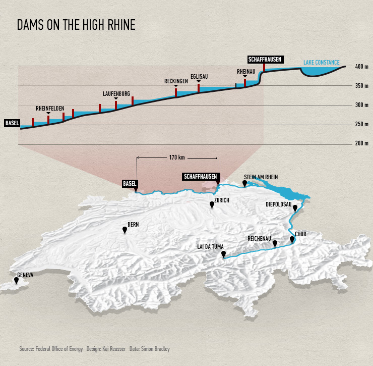
Pinpointing the dams along the High Rhine
Environmental costs
This river trip as you’ve probably guessed is actually a road trip – one that I’ve decided to take during the International Year of Water Cooperation.
I pull over next to the river tumbling over small boulders just below the town of Disentis. A danger sign suddenly stops me in my tracks, warning of the possibility of sudden flooding caused by hydroelectric plants. Now I know why there is no one here.
Hydropeaking – the sudden release of large volumes of river water through turbines during periods of high electricity demand – is one of the main problems on this stretch. Up to 1,000 km of watercourses in Switzerland are potentially affected by this artificial flooding, especially the Vorderrhein, its sister tributary the Hinterrhein, and parts of the Alpine Rhine stretching from Reichenau to Lake Constance.
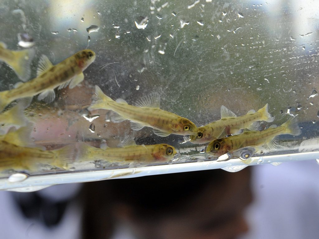
The costs to the environment can be high. Critics like Federal Environment Office water expert Diego Tonolla tell me that fish and other aquatic organisms can become stranded or washed away, fish spawning grounds destroyed, habitat reduced, and water temperature may be altered.
It is clear as I follow the river that the numerous dams and hydroelectric plants interrupt the migratory routes of aquatic organisms. Fish ladders designed to help them move upstream often do not exist or work. Dams also trap fine and coarse sediments like sand and gravel and wood debris which have an impact on wildlife and nature – like the natural reproduction of brown trout in the headwaters of the Alpine Rhine.
Just ahead of my trip the fish association “ProFisch Alpenrhein” rang the alarm bell, describing the regional situation as “catastrophic”. It urged the authorities and energy firms to implement mitigation measures agreed in the 2011, such as diverting or discharging the surge separately, or reducing and smoothing the flow regimes in and out of plants.
Affected cantons like Graubünden and power company Axpo say they are preparing mitigation plans for the end of 2014. But actual work on specific stretches of the river is not expected to be completed before 2030.
The other big problem is the low level of river water below many hydroelectric plants. Since 1992, legal requirements spell out the minimum amount of water to be maintained in streambeds. But only 16 out of 26 cantons are set to meet this target by 2015. Graubünden has been dragging its feet, but blames a recent legal case.
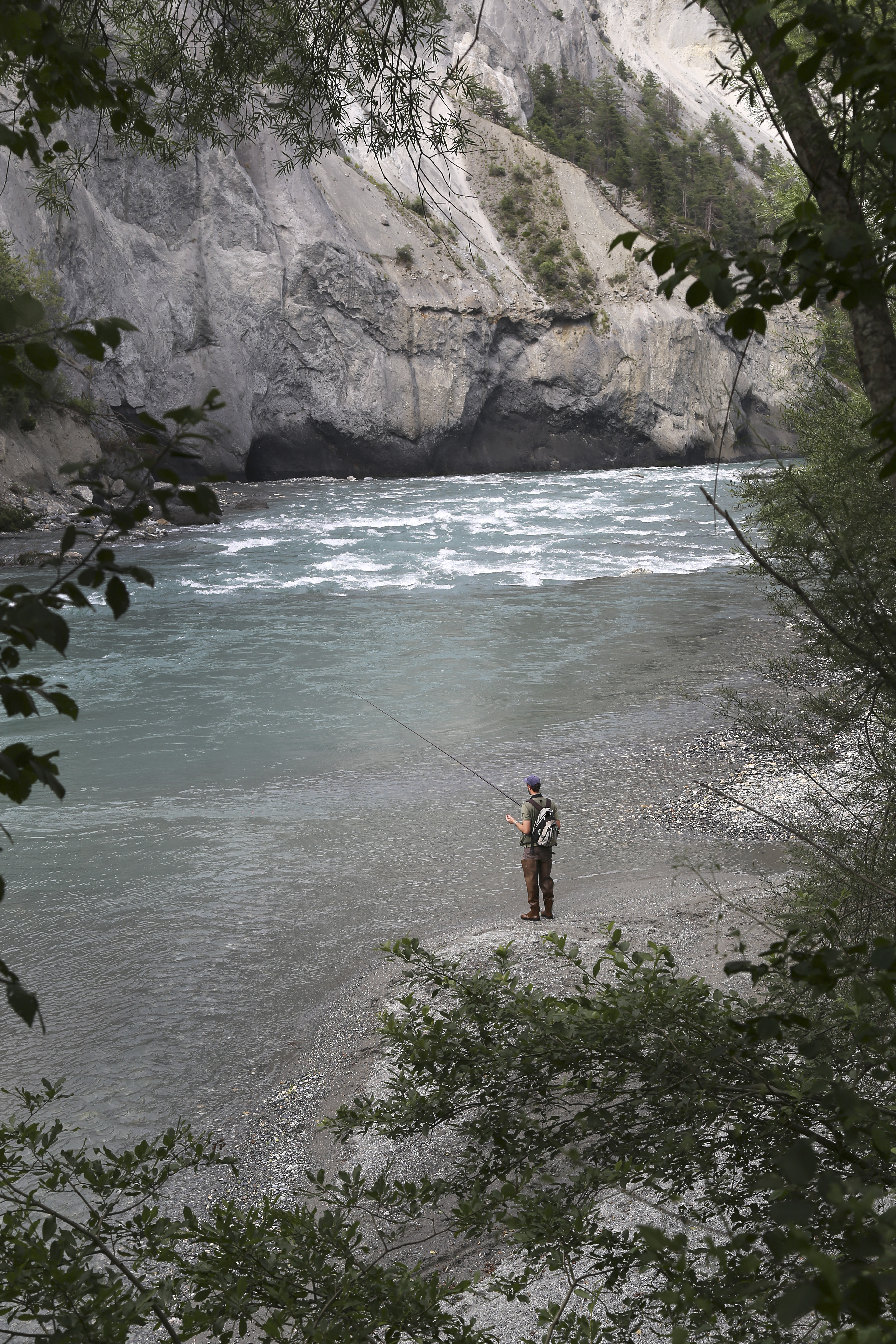
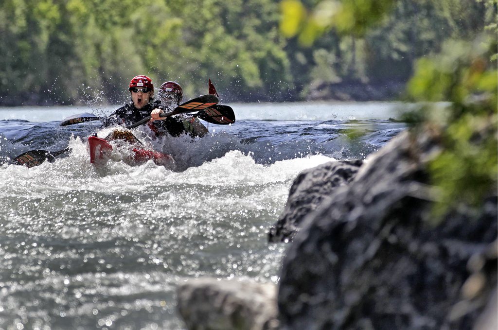
At the tiny hamlet of Valendas I walk to the river’s edge where screaming white-water rafters coast by. Here, the river has rediscovered its wild side, tossing the boats over rapids as it weaves past huge limestone pinnacles at the entrance to the Ruinaulta, Switzerland’s Grand Canyon.
A few kilometres further on the river changes again. Exiting the gorges at Reichenau, the Vorderrhein meets the Hinterrhein descending from the San Bernardino Pass. The new mix is a muddy-brown soup.
In a concrete corset
From here the ancient city of Chur, fertile fruit- and wine-growing regions and the area promoted as Heidi’s homeland are all a blur as I speed up the motorway alongside the river flowing north.
Along this 80km stretch, the river swells as major tributaries join from the east and the valley floor gradually widens. Several hundred years ago the Rhine used to weave its way across the entire valley. At Triesen just south of Liechtenstein the river bed was more than a kilometre wide.
But from the end of the 19th century man drastically corrected the river to protect against flooding. The gain in farmland was offset by a loss in biodiversity. Stuck in a straight 100-metre-wide corset up to Lake Constance, it appears completely tamed.
Some people have a different vision for its future, however. Inspired by his work on the island-braided floodplains of the Tagliamento River in northeast Italy – home to a rich ecosystem, WWF expert Lukas Indermaur dreams of renaturalising parts of the Alpine Rhine.
“The Rhine is like a living organism and we need to take care of it,” he tells me overlooking the river at Diepoldsau. “It’s got huge potential for biodiversity, a migration corridor between the pre-Alps and the Alps.” He is referring to the length of river between Chur and Lake Constance without any hydroelectric plants.
Large river conservation projects tend to stay on paper. But one Swiss-Austrian initiative that is moving ahead and also making waves is Rhesi, the name for a CHF600 million flood prevention and renaturalisation project over a 30km stretch between the mouth of the Ill tributary above Lichtenstein and Lake Constance.
Aimed at protecting the region and its 300,000 inhabitants from a possible once-every-300-year flood that could cause billions in damage, discussions over the project heated up last autumn when two options were presented publicly. Some worry that the more ecological solution could mean the loss of drinking water sources and 450 hectares of farmland. More studies have been commissioned and the start date to the 20-year project has been pushed back to 2019.
More
Bringing back salmon along the Rhine
Wildlife-tourist playground
As I walk along the New Rhine Canal to the mouth of the river, dragonflies playfully zip around my head. Nearby, the milky lime-green water glides past a digger scraping the river bed for gravel and other heavy deposits which it dumps into a waiting barge.
Every year an estimated three million cubic metres of debris flow into Lake Constance. To prevent the river mouth silting up dredging has become a full-time business.
The Rhine delta, a triangular zone between the canal, built in 1900, and the original Rhine extends over 2,000 hectares and is home to a rich fauna – 600 different plants and 300 different birds, such as the common tern and little ringed plover.
An estimated two million people live around central Europe’s third biggest lake. Its 48 billion cubic metres of drinking water are a valuable reservoir for four million people, including the residents of the German city of Stuttgart 120km away. The lake is also a busy playground for holidaymakers.
During my brief walk across the delta, apart from the odd frisbee and other small bits of plastic, there appears to be little man-made flotsam littering the shores and the water looks pretty clean. And if 2011 research by the International Water Protection Commission for Lake Constance is to be believed, things like micro-pollutants are not a major issue here either.
At the outflow of the Untersee (the smaller of the two lakes that form Lake Constance) at the mediaeval town of Stein am Rhein youngsters leap from the main bridge into the river.
My journey slows as I cruise along the Swiss-German border past the picturesque village of Diessenhofen and riverbanks lined with reeds and alluvial forests.
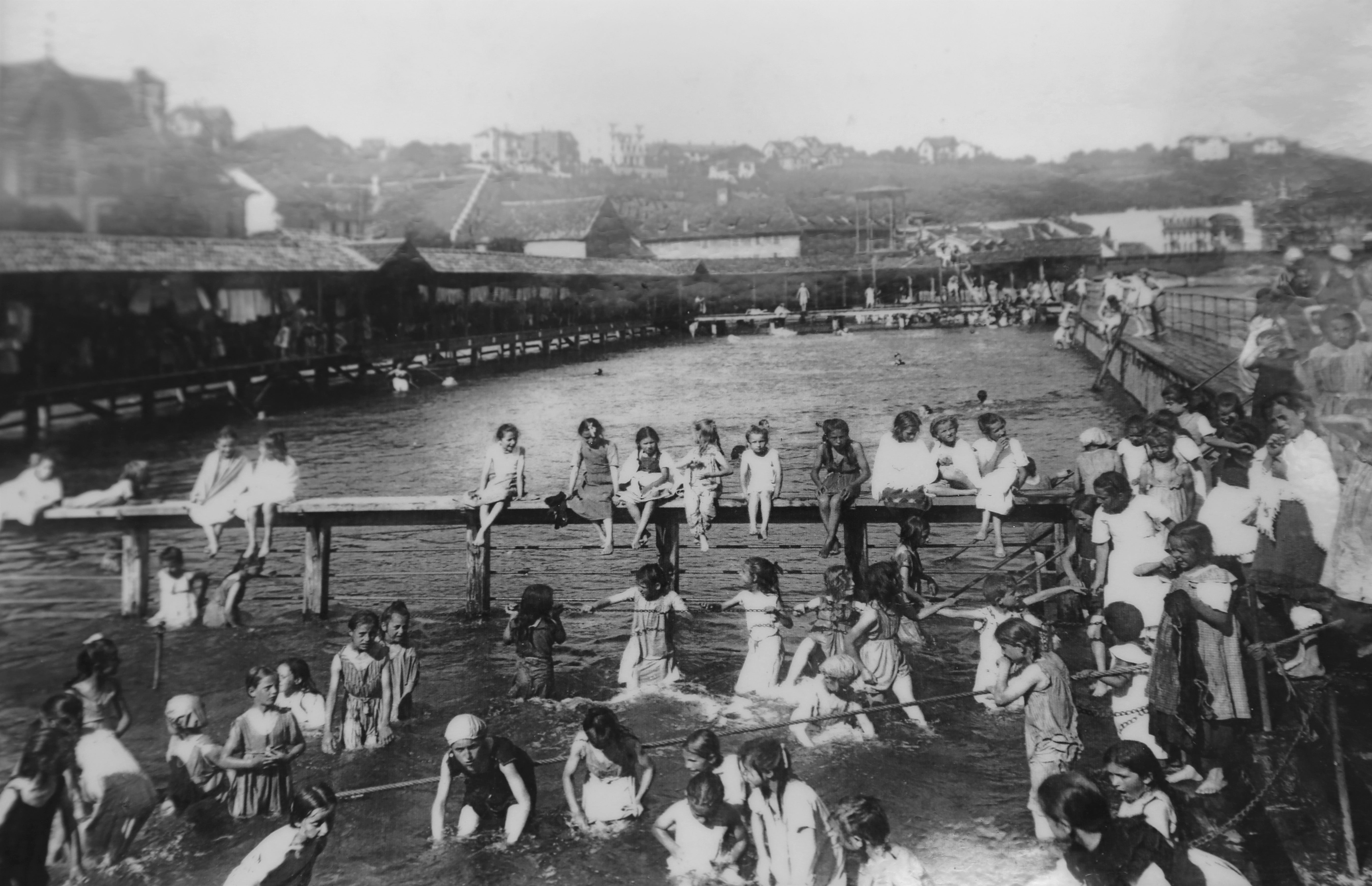
At the entrance to Schaffhausen bathers – young and old – cool off in the Rhybadi wooden river pool, completed in 1870.
Energy and industry
The historic baths were built 30 years before the erection of the Schaffhausen dam, the first of eleven found along the 165-km-long High Rhine westwards to Basel.
Standing at the top of the dam’s concrete wall with the river roaring beneath us, Samuel Gründler, a fish biologist from the local branch of the Swiss Fishing Association, tells me how dams have dramatically altered the character of the river in this section.
“You don’t have hydropeaking along the High Rhine. The main problem is the dams as the fish are unable to migrate. The current slows and the environment changes. It goes from a river to a lake ecosystem,” he explains.
The Swiss and German authorities want to do something to improve eroded riverbeds and other environmental damage caused by the dams. In March the Federal Energy Office presented a comprehensive joint plan to get local authorities and energy firms to reactivate river-bed sediment in certain sections.
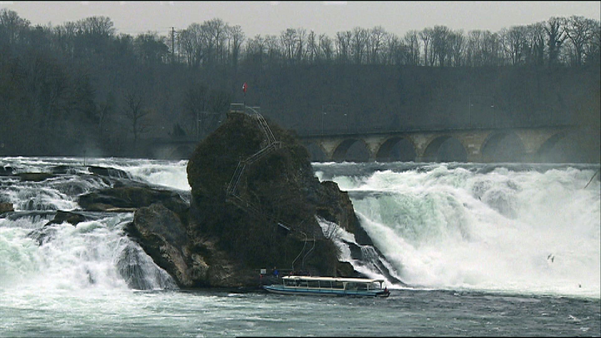
Not far south the valley narrows. Tourists snap away crazily as water crashes 23 metres over the 150-metre-wide river at the Rhine Falls – Europe’s most powerful waterfall.
From here it gouges a more languid, mundane path between the slopes of the Black Forest and the Jura foothills. Apart from a few free flowing sections like the rapids at Koblenz, the river is once again under man’s control.
The huge energy demands placed on the river become obvious as I pass the Leibstadt nuclear plant, Switzerland’s biggest, and Swissgrid, the national grid company’s centre at Laufenburg. One-fifth of all Swiss current passes through here.
Its economic importance becomes even more pronounced as we approach Basel with inland ports at Muttenz and Birsfelden and another north of the city up to the French-German border.
Despite the industrial activity, nature still manages to secure a foothold.
Urs Chrétien from Pro Natura points to a newly built lodge on a riverbank at Grenzach-Wyhlen, near Basel: “If I was a beaver I wouldn’t live next to the BASF chemical factory, but he’s here.”
Since 1956 beavers have been slowly reintroduced into Switzerland. In the built-up canton of Basel Country half a dozen families live along the Rhine and its tributaries, helped by organisations like Pro Natura. Fellow environmentalists from WWF hope similar efforts for the salmon can encourage its return to the Rhine and Aare.
More
Nature’s beauty versus power production
Cool banks and clearer waters
Red, yellow and blue waterproof bags shaped like fish bob up and down on the surface of the green shimmering water. Dodging the odd ferry, they drift past the red-brick cathedral, before emerging with their owners on the riverside steps amid hundreds of locals basking like seals.
For the people of Basel a dip in the cool Rhine waters is an essential summer pastime, along with hanging out with friends on the sunny riverbanks in Kleinbasel district.
The river water is now much cleaner ever since emergency clear-up and monitoring measures were introduced following the 1986 major chemical spill and fire at a riverside warehouse belonging to chemicals company Sandoz. The accident at the Schweizerhalle site was one of Europe’s worst environmental disasters.
At Weil am Rhein north of Basel a discrete white building next to the river is home to the Swiss-German International Rhine Monitoring Station, created in 1986 following the Sandoz disaster. It acts as a one of seven important warning stations constantly checking water quality, temperature and carbon dioxide levels.
Inside, Paul Svoboda, canton Basel’s head of water and pollution matters, points to a wall of charts and graphs. He is convinced the water quality has improved dramatically.
“You can see it in the measurements,” he tells me. “You have substances that have not only reduced but are no longer detectable, such as the herbicide atrazine that was banned in Germany in 1991 and in Switzerland in 2012.”
Water samples are taken on a daily basis and sent to a lab in Basel where they are analysed using a high-resolution mass spectrometer. Since the beginning of 2012, precise daily screenings of over 300 substances in the water are possible.
Since the 1990s the focus of their work has shifted from heavy metals, foodstuffs and chlorinated products to pesticides, pharmaceuticals, daily household chemicals and other micro-pollutants.
Here the Swiss are one step ahead of their neighbours Germany and France, Svoboda tells me. The Swiss authorities want to introduce additional processes like ozonisation and UV treatment at 100 out of 700 water treatment plants that could eliminate up to 80 per cent of micro-pollutants. This autumn parliament is set to discuss the financing of the new measures, which could cost CHF1.2 billion and take 20 years to implement.
Back in 1986 the Sandoz chemical accident turned the Rhine red. On this sunny day the water is greenish-blue.
“It’s clean enough to swim in, but I wouldn’t drink it,” says Sara, my hotel receptionist in Basel.
The sun is again beating down so I decide to follow her suggestion. With the Basel anthem “Z Basel a mym Rhy” (‘In Basel on my Rhine’) ringing in my ears, holding tightly onto my red waterproof ‘Wickelfisch bag’ containing my clothes and with my mouth firmly closed, I plunge into the shimmering water.

In compliance with the JTI standards
More: SWI swissinfo.ch certified by the Journalism Trust Initiative
You can find an overview of ongoing debates with our journalists here. Please join us!
If you want to start a conversation about a topic raised in this article or want to report factual errors, email us at english@swissinfo.ch.