Radar may reveal Mayan rituals
An archaeologist from Zurich is hoping to shed light on the Mayan civilisation of Central America using computer modelling techniques he has successfully employed in Switzerland.
Jürg Leckebusch of the cantonal archaeology office is a specialist in the use and interpretation of ground penetrating radar (GPR).
He has been asked to take part in a project in Mexico at Chichen Itza, a Unesco World Heritage Site, in Yucatan.
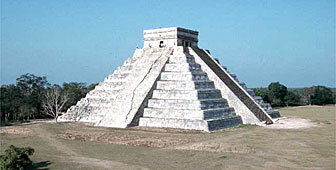
Leckebusch will be helping to investigate an area near the Castillo pyramid – also known as the pyramid of Kukulcan – where United States archaeologist, Larry Desmond, believes a cave used by the Maya for ritual purposes is located.
“We are trying to determine where it is and we will use GPR and computer programmes, used by Jürg, to generate a three-dimensional model of the subsurface,” said Desmond.
Unexplained trench
In the central part of Chichen Itza, the Maya created a large flat open space or plaza for ritual purposes and processions. They topped the bedrock with four metres of fill, which they paved with a kind of plaster concrete.
Within the fill, archaeologists have already detected what seem to be the foundations of previous buildings, as well as an unexplained trench, which was dug about ten to 15 metres from the west side of the pyramid.
The trench, which runs in a north-south direction, is at least 100 metres long and five metres wide, and, in places, goes into the bedrock. It was dug after the plaza was completed and then refilled.
“One theory is that it might have been used as an access to a chamber underneath the pyramid – maybe a burial chamber or a ritual chamber,” said Desmond. “Maybe it was used on a one-time basis when they buried a later king of Chichen Itza.
“We don’t really know and that’s why we’ll be doing a ground-penetrating radar project to try to generate a 3-D model to give us a better idea. If needed, we will follow that up with an excavation.”
Fancy footwork
Desmond, a senior research fellow with the Mesoamerican archive at the Peabody Museum of Harvard University, said it would take some “fancy GPR footwork” to detect the cave under the pyramid. “All sorts of indirect evidence will need to be reinterpreted,” he added.
That is where Leckebusch comes in with his ability to generate three-dimensional computerised models based on the GPR data. This has already been successfully demonstrated at the Roman city of Augusta Raurica near Basel.
In his office in Zurich, Leckebusch can call up on his computer screen, models of structures which are still standing underground – pillars, water channels, former entrances, which were subsequently covered up, and the heating floors of a Roman bath. Thanks to GPR, all this is visible without the need to excavate.
“With geophysical prospection methods, you can see into the ground without touching any of these structures,” said Leckebusch. “Using geophysical techniques, you can understand what’s in the ground and then start to excavate.”
Need to dig
Non-intrusive methods are particularly important at a World Heritage site, added Desmond. “Ground-penetrating radar and other geophysical methods can identify specific locations so you can focus your work.”
Leckebusch is quick to stress that his techniques do not provide all the answers.
“Unfortunately, geophysical prospection does not replace conventional excavation,” he said. “If you want to know the exact date or the exact relationship of several walls together, you have to dig it out; and also today you’d never be able to capture any ceramics or any single objects. They’re too small to be detectable by these methods.”
Computer models
In Switzerland, Leckebusch uses a unique contraption he designed himself – essentially a drivable lawnmower on which he has installed all his electronic equipment. He can survey up to a hectare a day.
“This was all done manually,” he said, pointing to the computer models of Augusta Raurica. “It took quite a few weeks to get a complete understanding of the structures, but even if it’s done by hand, it’s much faster than excavating it. Excavating an area of one hectare would take more than ten years.”
Now the hope is that he will be able to generate similar models by surveying the Great Plaza of Chichen Itza.
Chichen Itza boasts some of the most impressive architecture of Mayan civilisation. Most archaeologists agree that it flourished from about the fifth to the 15th centuries AD.
International collaboration
Leckebush and Desmond will be working in collaboration with Mexican geophysicist, professor Rene Chavez, of the National Autonomous University of Mexico; archaeologist James Callaghan, Director of the Kiuic Biocultural Reserve, Yucatan, Mexico; and US geophysicist, professor William Sauck of Western Michigan University.
Sauck and Desmond carried out GPR surveys at Chichen Itza in 1993, when the trench near the pyramid was detected, and 1997.
The current project will build on the results of this earlier work. They hope to have funding arranged next year.
by Vincent Landon

In compliance with the JTI standards
More: SWI swissinfo.ch certified by the Journalism Trust Initiative
You can find an overview of ongoing debates with our journalists here. Please join us!
If you want to start a conversation about a topic raised in this article or want to report factual errors, email us at english@swissinfo.ch.