Swiss software helps clear landmines
The removal of landmines from conflict regions around the world has received a boost from computer software developed in Zurich.
The product, developed by scientists at the Federal Institute of Technology, helps demining experts use their resources to maximum benefit.
It also leads to the rapid printing of maps, which inform civilians which areas they should avoid.
The Information Management System for Mine Action (IMSMA) is approved by the United Nations and has been adopted as standard by other international organisations, as well as by the European Union and the United States.
IMSMA was employed for the first time in Kosovo and is now in use in 30 countries, including Iraq.
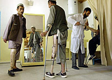
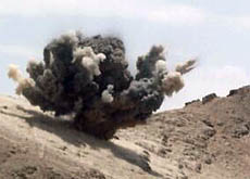
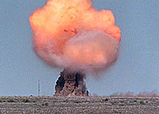
According to the US state department, there are 50 million mines lying in the ground worldwide. The Zurich-based World Without Mines Foundation estimates that a mine explodes somewhere in the world every 30 minutes.
These tend to kill or maim civilians long after the fighting has stopped.
Priorities
“It can take months to demine a minefield,” explained software specialist, Reto Häni, from the centre for security studies at Zurich’s Federal Institute of Technology.
“It is important that they’re cleared where it makes a difference to the local population.
“There are still a lot of mines from World War Two in the desert but nobody goes there. However, a single mine blocking access to a school can have quite a significant impact on the lives of a whole community.”
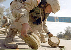
By feeding a wide range of information into a computer, IMSMA offers a quick and accurate way of assessing the size and location of minefields and where unexploded bombs are lying about.
The data may include maps from the warring parties, reports of previous accidents from landmines, where aircraft have dropped ammunition, and interviews on the ground if people have seen soldiers laying mines.
Häni admitted that computer software alone was not going to solve the problem of landmines, but he said it could help determine priorities so that scarce demining resources were used to maximum benefit.
Life and limb
The information is also used in programmes to make civilians aware of the danger of mines.
“One of the main goals is to reduce the number of mine victims,” Häni told swissinfo. “If you can print maps of where it is dangerous to go, people will avoid these hazardous areas.”
The Geneva International Centre for Humanitarian Demining says the software, which is a combination of database and geographical information system (GIS), has benefited peacekeeping troops, the local population and non-governmental organisations.
“In general, the problem with landmines is not so much to deactivate them but to find them in the first place,” said spokesman Davide Orifici.
“With this information management system, you can develop detailed maps of certain parts of the country.”
The six countries most affected by landmines are Cambodia, Afghanistan, Mozambique, Angola, Nicaragua and Bosnia-Herzegovina.
In 1997, the Ottawa Treaty issued an international ban on antipersonnel landmines.
swissinfo, Vincent Landon
There are an estimated 50 million mines lying in the ground worldwide.
These tend to kill or maim civilians long after the fighting has stopped.
The six countries most affected are Cambodia, Afghanistan, Mozambique, Angola, Nicaragua and Bosnia-Herzegovina.
In 1997, the Ottawa Treaty issued an international ban on antipersonnel landmines.

In compliance with the JTI standards
More: SWI swissinfo.ch certified by the Journalism Trust Initiative
You can find an overview of ongoing debates with our journalists here . Please join us!
If you want to start a conversation about a topic raised in this article or want to report factual errors, email us at english@swissinfo.ch.