Leica Geosystems sizes up the world
The takeover battle for Swiss measuring group Leica Geosystems over the past few weeks has tended to overshadow what the company actually manufactures.
Based at Heerbrugg in canton St Gallen, the firm produces sophisticated equipment that surveyors, engineers, mapmakers, architects and others use to make precision measurements.
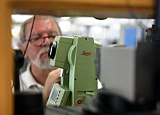
“We produce instruments that can measure distances, surfaces and volumes in the broadest sense,” Leica’s chief executive Hans Hess told swissinfo.
The instruments use technologies including laser distance tracking, the global positioning system (GPS) and others to help the experts who build bridges, tunnels, roads, aircraft or maps.
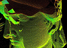
They are used to capture, analyse, model and present spatial data, including in three dimensions (3D).
Highest bridge
The company’s equipment and software solutions were used in the planning and construction of the world’s highest bridge above the Tarn valley in southern France and now monitor the bridge’s movement and material stresses.
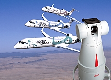
They were also used to help engineers assemble the world’s largest passenger aircraft – the new Airbus A380 passenger plane – to the greatest of accuracy.
“The way you mount the wing to a body of an aircraft, the way the fuselage comes together – this is all constantly measured with our instrumentation at 0.1mm precision,” Hess explained.
Closer to home, Leica’s equipment is being used to plan and construct the new rail tunnels through the Lötschberg and Gotthard, as part of the New Rail Links through the Alps (NRLA) project.
The drilling machines are aligned with the company’s equipment so that there is no possibility of tunnel workers not meeting at the various locations along the way.
Leica instruments are also keeping a watchful eye on dams and lakes located above the NRLA tunnel workings looking for any possible changes.
Looking back
While many of the company’s instruments are mapping the future of construction, some have been taking a good look at the past.
One of the latest triumphs was unlocking the design secrets of the Byzantine church of Saint Sophia in the Turkish city of Istanbul, considered by many historians the eighth wonder of the world.
In a project sponsored by the Swiss National Research Foundation, we now know how scientists and artists working in the sixth century managed to build a freely suspended dome almost 56 metres high and 31 metres wide, supported by just four pillars.
“It’s very interesting for people who do research to try to understand these structures not only from a picture point of view, but also to try to understand with millimetre-precise measurements how they were built and what the philosophies and thoughts behind those structures were,” Hess explained.
Most expensive
The most expensive piece of equipment Leica Geosystems produces is a kind of digital air-borne camera that captures the surface of the Earth and is used for mapping purposes.
At around SFr2 million ($1.57 million) each, they are used in particular by governments, including Switzerland’s federal office of topography and Britain’s Ordnance Survey mapping agency.
Leica Geosystems is also increasingly providing the software that can process the growing amount of data that comes in digital format.
At the other end of the scale, the company produces laser rulers that make life easier for do-it-yourself enthusiasts by replacing conventional tape measures.
“You don’t need a second person to hold one end of the tape,” Hess said. “There is significant productivity and it’s actually more fun to measure with a laser ruler.”
Innovation basket
As a response to weak economic situations in 2002 and 2003, the company put its eggs in the innovation basket, with the result that new products made an impressive contribution to sales.
“It’s impressive for me as the CEO,” he enthused. “Never has our company had a situation where half of its revenue in one year came from products that were less than 12 months old.”
But the problem with success has been that Sweden’s Hexagon made a hostile bid for the company in June and Danaher of the United States entered the arena as a white knight or friendly bidder (see related items).
“I think more than one investor has seen that we are a very attractive company, that we have a bright future. We have not exhausted the potential in the market place.
“We have plans to grow and prosper as we go forward and that has created an appetite for certain investors. Secondly, I think they perceive us as relatively cheap compared to companies in other markets,” Hess said.
swissinfo, Robert Brookes in Heerbrugg
The history of Leica Geosystems can be traced back to 1819, with the founding of the Kern company in Aarau.
A little over 100 years later, in a small empty textile mill in Heerbrugg, Heinrich Wild was busy developing the T2, the world’s first truly portable opto-mechanical theodolite and building the foundation of modern surveying.
Leica Geosystems is independent of Leica Cameras and Leica Microsystems in Germany.
The company was floated on the Zurich stock exchange in 2000.
The largest object that a Leica Geosystems instrument measures is the Earth. Researchers want to find out, among other things, how the planet’s crust is deforming and how tectonic plates move.
Leica equipment has even been on the peaks of Mount Everest and K2 for this kind of research work.
Thousands of reference stations in Japan continually take measurements, helping to predict earthquakes.

In compliance with the JTI standards
More: SWI swissinfo.ch certified by the Journalism Trust Initiative
You can find an overview of ongoing debates with our journalists here . Please join us!
If you want to start a conversation about a topic raised in this article or want to report factual errors, email us at english@swissinfo.ch.