


Huge potential for Swiss 3D landslide simulation model

A new three-dimensional (3D) model developed by researchers at the Swiss Institute for Snow and Avalanche Research (SLF) can accurately predict the dynamics and extent of landslides.
Select your language
Generated with artificial intelligence.
Listening:
Huge potential for Swiss 3D landslide simulation model
+Get the most important news from Switzerland in your inbox
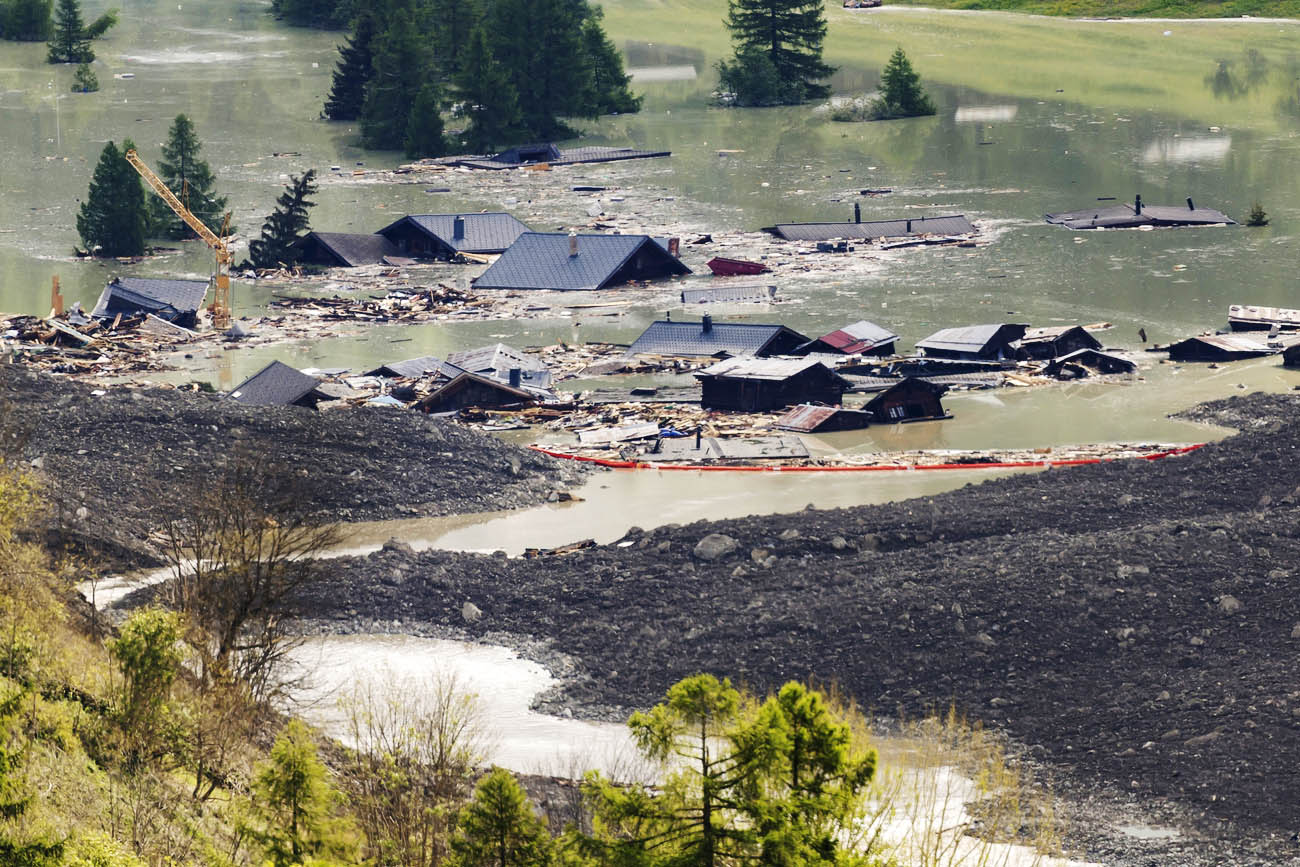
The instrument, while still in the development phase, correctly determined the extent of the one that buried Blatten on May 28. Now scientists are using it to simulate possible landslides at a dozen other locations in Switzerland.
+ Why do Swiss mountains collapse? It’s complicated
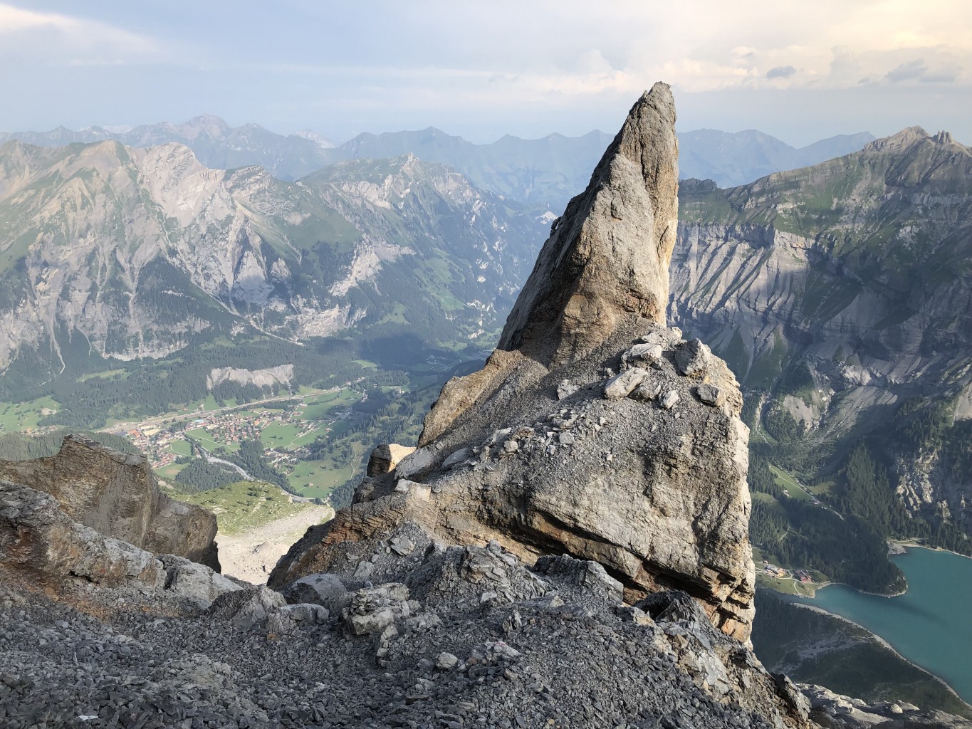
One such site is Bim spitze Stei, a rock outcrop on an unstable mountainside overlooking the Oeschinensee lake to the south, near Kandersteg, Johan Gaume, a researcher at the Swiss Federal Institute of Technology Zurich (ETH) and the SLF, told Keystone-ATS. Together with colleagues, he developed the new model.
More
Climate threats: living in the shadow of a crumbling mountain
The 3D tool proved its effectiveness for the first time in Brienz/Brinzauls, the hamlet in the Graubünden municipality of Albula/Alvra that has been threatened by a landslide for several years. After the evacuation of the village in 2023, the model correctly predicted that the rock mass would stop just before the houses most exposed to the landslide. The researchers had informally shared this assessment with the cantonal authorities before the events.
+ One in six Swiss homes exposed to natural hazards
Correct simulation for Blatten
When the threat of a landslide appeared in Blatten last spring, the researchers from the Davos institute carried out simulations there as well. The aim was to test the prediction model in an even more complex scenario than that of the Albula/Alvra valley, because in the Lötschental, in addition to rock and debris, there was also the glacier variable.
Initially, boulders and stones detached from the flank of the Kleines Nesthorn, on the left side of the valley, had in fact accumulated on the Birch glacier (Birchgletscher). Overall, the morphology of the terrain in this corner of Upper Valais is more complex than that of the Rhaetian site.
The result of the simulations surprised the scientist: the landslide would almost have reached Weissenried, a hamlet of Blatten on the opposite side of the Kleines Nesthorn, 200 metres above the valley floor. “It seemed a bit unrealistic,” Gaume pointed out.
Since the model was still being developed, the researchers proceeded cautiously, deciding to verify the result with other colleagues before sharing it with the authorities.
But the landslide preceded them and the simulation turned out to be correct: the village of Weissenried was almost entirely covered by debris and ice. “Now we know we have a powerful tool and are ready for the next event,” said Gaume.
More
Blatten: what price for preserving Swiss mountain life?
The great strength of the new model is that, unlike those previously used, it generates simulations that are not only two-dimensional. “Rock slides are complex 3D processes and, with our model, this complexity naturally emerges from the physics of the simulation,” the researcher explained. Two-dimensional tools, for example, are unable to detect when the sliding mass detaches from the ground or how exactly it reacts to steep and changing topography.
The researchers are currently working on simulations of the Bim spitze Stei peak, among other things. Since 2019, a large rock mass has been on the move and the authorities fear a landslide. With their model, the researchers are now simulating possible worst-case scenarios.
Unlike other models, the 3D model is able to simulate the interaction between a possible landslide and the underlying Oeschinensee, according to Gaume. When large amounts of rock fall into a lake, they can cause dangerous flood waves that in turn threaten hiking trails or other infrastructure. The 3D model makes it possible to predict and study this scenario.
Translated from Italian by DeepL/mga
We select the most relevant news for an international audience and use automatic translation tools to translate them into English. A journalist then reviews the translation for clarity and accuracy before publication.
Providing you with automatically translated news gives us the time to write more in-depth articles. The news stories we select have been written and carefully fact-checked by an external editorial team from news agencies such as Bloomberg or Keystone.
If you have any questions about how we work, write to us at english@swissinfo.ch
External Content

In compliance with the JTI standards
More: SWI swissinfo.ch certified by the Journalism Trust Initiative
You can find an overview of ongoing debates with our journalists here . Please join us!
If you want to start a conversation about a topic raised in this article or want to report factual errors, email us at english@swissinfo.ch.