Laser maps Swiss weather in 3D
Laser technology is being used to produce real-time 3D maps of atmospheric humidity that should revolutionise weather forecasting in Switzerland.

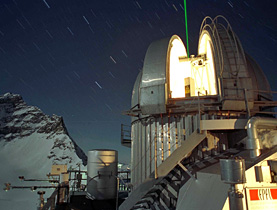
A Light Detection and Ranging (Lidar) weather measurement system was officially launched at the MeteoSwiss weather forecasting headquarters in western Switzerland on Tuesday.
The high-tech instrument is the only one of its kind in the world able to provide continuous data on the vertical distribution of humidity in the atmosphere up to an altitude of 10km.
It works by firing a laser beam vertically into the sky 30 times a second, then measuring the “echo” – light reflected back from different layers in the atmosphere – to build instantaneous vertical profiles of humidity.
The innovative system can also detect fine particles, including pollen, and from 2010 will be able to build up 3D temperature profiles.
According to MeteoSwiss, the spatial and temporal resolution of the new laser system should make a big difference to the accuracy of weather forecasting.
“It’s a huge advance,” Bertrand Calpini, head of the MeteoSwiss Aerological Station in Payerne, told swissinfo. “To go from the laboratory to a weather service that can measure humidity continuously is a real breakthrough.”
Integrating real-time humidity profiles into our forecasting models will be a clear improvement, as currently we don’t know if there are dry or humid layers at 1,000 metres, for example, he explained.
It will also play an important role in the evaluation of global warming at a time when the climate is becoming a major issue, said Patrick Aebischer, president of the Lausanne-based Federal Institute of Technology (EPFL), which developed the measurement system.
The project is the result of 20 years’ research and development at the EPFL, in collaboration with MeteoSwiss, funded partly by the Swiss National Science Foundation.
“The project is an excellent example of technology transfer from a federal school to a federal office,” added the EPFL president.
Complementary system
The new system will be a vast step up from weather balloons that take minutes to reach the upper atmosphere and can be sent out only a few times a day. However, it will not totally replace existing forecasting tools.
Unfortunately, the new system can only be used two-thirds of the time, said Calpini.
“When it’s raining or snowing or with low cloud cover, the system is blind and can’t work. The laser light can’t get through the clouds,” he said. “There is no way around it.”
As a result, it will complement traditional instruments: a ground-based measurement network, balloon-launched probes, radar equipment, wind speed and temperature measurements, and a station of the Baseline Surface Radiation Network, part of a worldwide network that measures radiation changes at the Earth’s surface.
The World Meteorological Organization is closely following the new laser, as this type of ground-based remote-sensing technology will help replace and improve global systems, said Calpini.
For the moment, the Swiss instrument is the most highly advanced and surpasses the capabilities of similar research projects in Germany, the United States and the Netherlands.
Necessary investment
Officials were vague about the overall cost of the innovative project, “SFr750,000 for the hardware and 20 years’ research work which amount to millions”. But the investment is worth it, they claim.
“The Lidar will serve as a reference for future or existing systems, especially since this kind of remote sensing is experiencing rapid development,” said project leader and EPFL Professor Hubert van den Bergh.
Despite the high costs, these are exactly the kind of accurate, high-tech measuring instruments a mountainous country like Switzerland needs, said Calpini.
“If you go from the north to the south within 200km you go from 4,000-metre mountains to places close to sea level,” he said. “It’s extremely difficult to make weather forecasts in Switzerland.”
swissinfo, Simon Bradley in Payerne
MeteoSwiss, part of the Interior Ministry, provides the population, public bodies and businesses with meteorological and climate information.
It employs around 270 people. 800 non-professional observers man its recording stations.
Half of its budget is allocated by the federal authorities. The remainder comes from payments for the services it provides.
Meteorological data has been gathered in Switzerland since 1863, when 88 weather stations were set up by the Swiss Society of Natural Science.
1881: the government decided to establish the Central Meteorological Institute, now MeteoSwiss.
1927: to meet the needs of the growing aviation industry, an aeronautical meteorological service was established.
1936: an early warning service for storms was introduced for the Alpine region and for the Swiss lakes.
1951: a meteorology service for agriculture was set up.
1993: MeteoSwiss began providing daily pollen count information.
Light Detection and Ranging (Lidar) is an optical remote sensing technology that measures properties of scattered light to find the range and other information about a distant target.
Like radar technology, which uses radio waves instead of light, the range of an object is determined by measuring the time delay between transmission of a pulse and detection of the reflected signal.
Lidar technology has various applications: meteorology, archaeology, geography, geology, geomorphology, seismology, remote sensing and atmospheric physics.

In compliance with the JTI standards
More: SWI swissinfo.ch certified by the Journalism Trust Initiative
You can find an overview of ongoing debates with our journalists here. Please join us!
If you want to start a conversation about a topic raised in this article or want to report factual errors, email us at english@swissinfo.ch.